UK Planning Maps: Location and Site Plan Guide
Learn what UK planning maps must show, including location and block plan scales, red-line boundaries, OS licensing, PDF files and CAD formats.

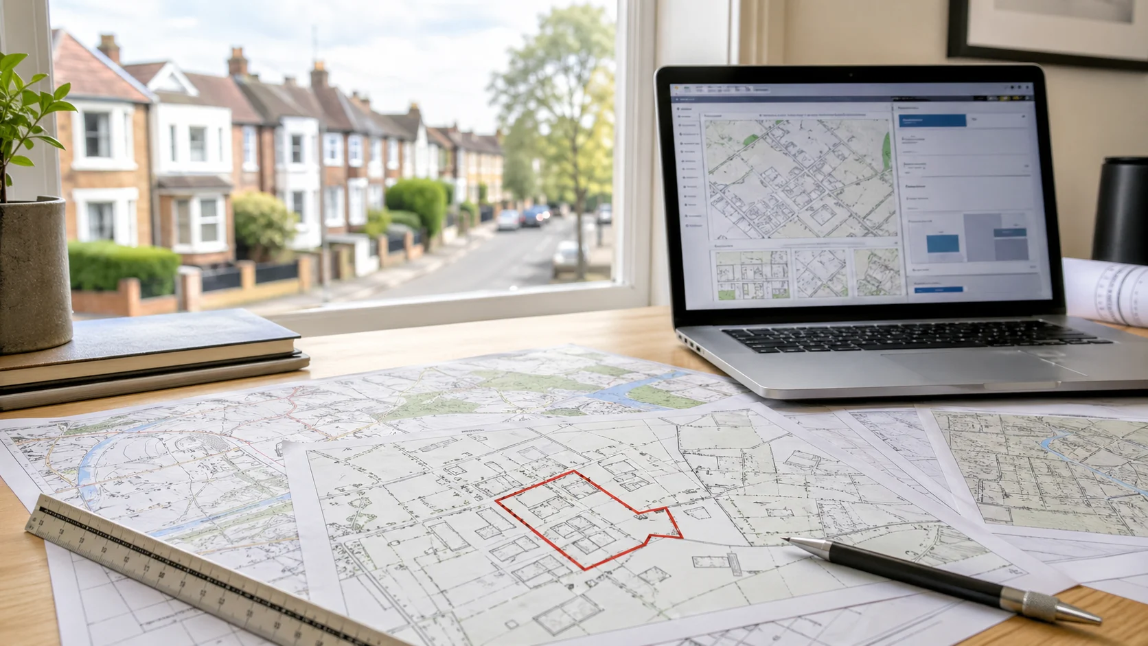
Quick Summary: What UK Planning Maps Need to Show
Planning applications usually begin with maps, not drawings. A compliant set should identify the application site, show its relationship to surrounding land, use the correct metric scale, include a north point, and be based on properly licensed Ordnance Survey data. For most projects, that means a location plan at 1:1250 or 1:2500 and a site plan, also called a block plan, at 1:500 or 1:200. If you need an OS-licensed location or block plan, Planning Maps UK provides both formats. Getting these documents right helps the local planning authority validate the application quickly and understand the proposal without avoidable queries.
A common mistake is to submit a Google Maps screenshot for a small project such as a dropped kerb. A council can reject it during validation because it is not a scale drawing based on licensed Ordnance Survey mapping data.
Why Planning Maps Matter Before an Application Is Valid
A planning map is not just an illustration. It is part of the evidence that tells the local planning authority exactly where development is proposed and what land is involved. Before a planning officer assesses design, neighbour impact, parking, drainage, trees, or heritage issues, the validation team checks whether the submitted plans meet national and local requirements.
GOV.UK guidance says a valid planning application normally needs plans and drawings, drawn to an identified scale with north shown where relevant. The Planning Portal similarly explains that most applications require a location plan and a site plan. One establishes the wider setting. The other explains boundaries, buildings, access, and nearby features.
If the map is missing, wrongly scaled, unclear, or unlicensed, the application may be delayed before it reaches the case officer. Good mapping is therefore a simple risk-control step. It makes the submission easier to validate, read, and discuss with planning officers, neighbours, and consultees.
Location Plans: Showing Where the Site Is
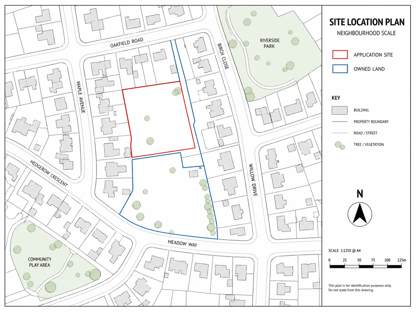
A location plan answers the first question in any planning submission: where is the site? It shows the property or land in relation to surrounding roads, buildings, plots, and landmarks. The plan should make it possible for someone who does not know the address to locate the site confidently.
The Planning Portal says a location plan should use an up-to-date map, a standard metric scale, and sufficient adjoining roads or buildings. It should also show the application boundary in red and any other nearby applicant-owned land in blue. This is why it is often called a red-line plan.
The Standard 1:1250 Scale
For typical urban and suburban applications, 1:1250 is the standard location-plan scale. It can usually show the application site, neighbouring properties, and enough road context to identify the land clearly on A4 or A3 paper. Councils often expect at least two named roads where possible.
The location plan is not intended to show construction detail. Its job is wider context. If it is too tightly cropped, the authority may struggle to confirm the location. If it is too zoomed out, the red line may become hard to read.
When 1:2500 Is More Suitable
Some sites need a wider view. Rural properties, farms, estates, equestrian land, and irregular plots may not sit neatly among named streets. A 1:2500 location plan may be more appropriate because it captures lanes, field boundaries, landmarks, and access routes. Planning Portal guidance recognises 1:2500 for larger sites.
The choice should be led by clarity. A rural plan may need labels, a visible access route, nearby buildings, or recognisable features. The aim is enough context for the authority to understand the land without ambiguity.
Red Line and Blue Line Boundaries
The red line is one of the most important parts of the submission. It should enclose all land necessary to carry out the development, including the building, garden, driveway, visibility splays, parking areas, landscaping, and access to the public highway. Drawing only around the house or works footprint is often too narrow.
The blue line has a different purpose. It identifies other land owned by the applicant that is close to or adjoining the application site. This helps the authority understand ownership context. The red and blue lines should be clear, continuous, and consistent with the rest of the application forms, including ownership certificates.
Site Plans and Block Plans: Showing What Will Change
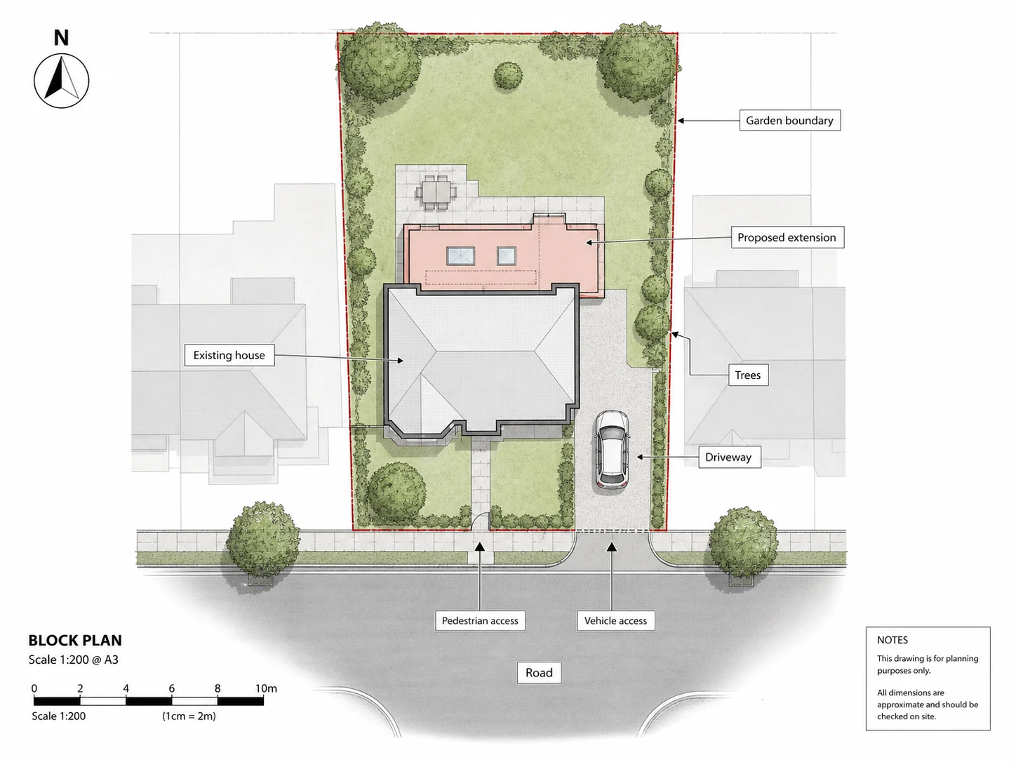
A site plan, often called a block plan, zooms in from the wider location plan. It explains the proposal within the site boundary and shows how the development relates to existing buildings, neighbouring land, highways, trees, hard surfacing, and access points.
Planning Portal guidance describes site plans as typically submitted at 1:200 or 1:500. Many councils use similar wording. The difference is purpose: the location plan says where the site is, while the block plan says what is happening on it.
Common 1:500 and 1:200 Scales
A 1:500 block plan is common for ordinary householder applications because it usually shows the whole plot, immediate neighbours, road edge, gardens, and main site features. It gives planning officers enough information to judge the proposal in relation to boundaries and adjoining properties.
A 1:200 plan gives more detail. It can be useful for smaller plots, dense urban sites, extensions close to boundaries, outbuildings, dropped kerbs, parking layouts, and projects where relationships between features matter. Larger scales may appear in architectural packs, but the site plan should remain clear and measured.
What Planning Officers Expect to See
Planning officers and validation teams expect a block plan to show the proposed development in relation to the site boundaries. It should show existing buildings, proposed buildings or extensions, adjacent streets, access arrangements, and relevant features. Depending on the project, that may include trees, boundary treatments, hard surfaces, rights of way, parking, levels, demolition, drainage, or refuse storage.
The plan should not force the officer to guess. If a neighbour's boundary, driveway, retained tree, or proposed hardstanding affects the assessment, it should be visible. Labels and dimensions can help, but they should not clutter the drawing. The best block plans are clean, scaled, and selective.
Existing and Proposed Site Details
Many applications benefit from separate existing and proposed site plans. Existing plans show the current lawful arrangement. Proposed plans show the development after works are complete. Planning decisions compare what is there now with what is being requested.
For a simple extension, the proposed footprint might be shaded against the existing building. For a new access, the plan may need to show the highway connection, driveway width, hardstanding, and visibility. For a garden room, it may show boundary distances, retained garden, trees, and neighbouring structures.
Scale, North Points and OS Licensing
Scale is fundamental because planning maps are measured documents. A planning officer may use the drawing to understand separation distances, plot relationships, access positions, and boundary proximity. If the scale is wrong, the interpretation can be wrong.
Every plan should state the scale and include a scale bar. A north point should be visible. The map should be based on current, licensed mapping. Ordnance Survey explains that applicants should obtain suitable large-scale mapping from OS licensed partners, not HM Land Registry title plans.
Why “Fit to Page” Can Cause Problems
Digital submission makes printing less common, but scale still matters. A correct PDF can become unreliable if printed using "fit to page" or inserted into another document at the wrong size. The scale bar lets anyone check whether distances remain proportionate.
For submissions, avoid screenshots, stretched images, compressed scans, or copied extracts. A clean PDF exported at the intended page size is usually safest. File names should make the contents obvious, for example "Location Plan 1-1250" or "Proposed Block Plan 1-500".
Why Licensed Ordnance Survey Mapping Matters
Planning maps often contain Ordnance Survey data, which is protected by copyright and database rights. Councils may expect the plan to show the relevant OS licence information. Using a search-engine screenshot, estate agent plan, old sales brochure, or Land Registry title plan can create copyright and validation problems.
Licensed OS-based mapping also gives the authority a familiar, consistent base. It shows roads, buildings, plot features, and topographic detail in a format planning teams recognise. That consistency helps reduce avoidable queries and makes the plan easier to compare with the council's own mapping systems.
PDF vs CAD: Which Format Should You Use?
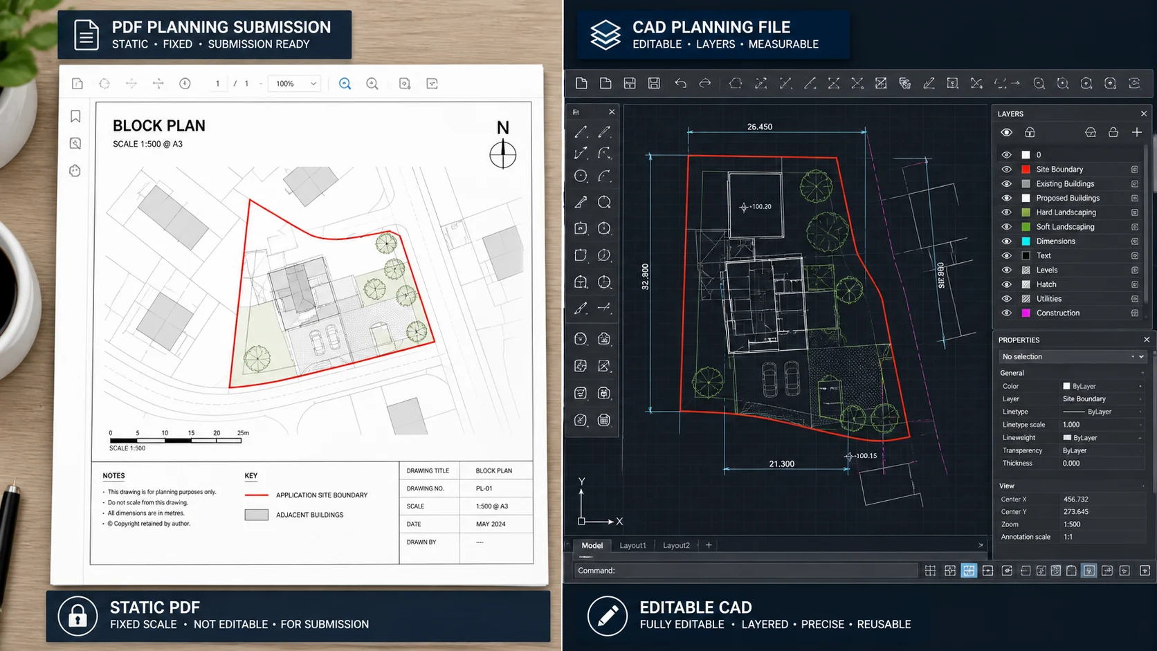
PDF and CAD files serve different purposes. A PDF is a fixed document for viewing, uploading, printing, and validation. CAD files, such as DWG or DXF, are working files for design teams who need editable vector linework.
PDF for Straightforward Planning Submissions
For most homeowners and simple applications, PDF is the practical format. It preserves the intended sheet size, layout, title, scale, north point, red line, and licence information.
PDF is also suitable when the map is complete and does not need further technical drafting. If the boundary has been drawn, the scale is correct, and the plan clearly shows the required information, a PDF can be the final submission document.
CAD for Architects, Designers and Technical Workflows
CAD is useful when the map will become part of a design workflow. Architects, surveyors, engineers, and consultants may need to import OS linework into AutoCAD, Revit, Vectorworks, SketchUp, or similar software. CAD allows accurate drawing, measuring, layering, and coordination.
Unlike a static PDF, CAD data can be edited and used as a base for technical drawings. That is valuable for complex sites, professional drawing packs, measured overlays, and design development. It is usually exported to PDF for submission.
When Both Formats Are Useful
Many professional projects use both. CAD supports drafting and design, while the PDF becomes the readable planning document. This keeps the workflow efficient without asking the authority to interpret technical files.
Common Reasons Planning Maps Are Rejected
Even small mapping errors can create validation delays.
Missing Access to the Public Highway
The red line should include land necessary for the development, including access where relevant. If a private drive, shared access, visibility splay, or route to the highway is needed, leaving it outside the red line can cause ownership and validation issues.
Incorrect or Unclear Boundaries
Boundaries should be precise and readable. A red line that cuts through buildings, misses part of the garden, excludes the works, or conflicts with the application form can trigger questions. Blue land should be shown where required.
Out-of-Date or Unlicensed Base Mapping
Old plans, copied screenshots, and unlicensed extracts are risky. Current OS-based mapping with proper licence information is the safer standard.
Poor File Naming or Unclear Plans
Validation teams handle large numbers of uploads. Clear titles, dates, scales, and file names help them identify each drawing quickly. Ambiguous uploads slow the process.
Practical Checklist Before You Submit
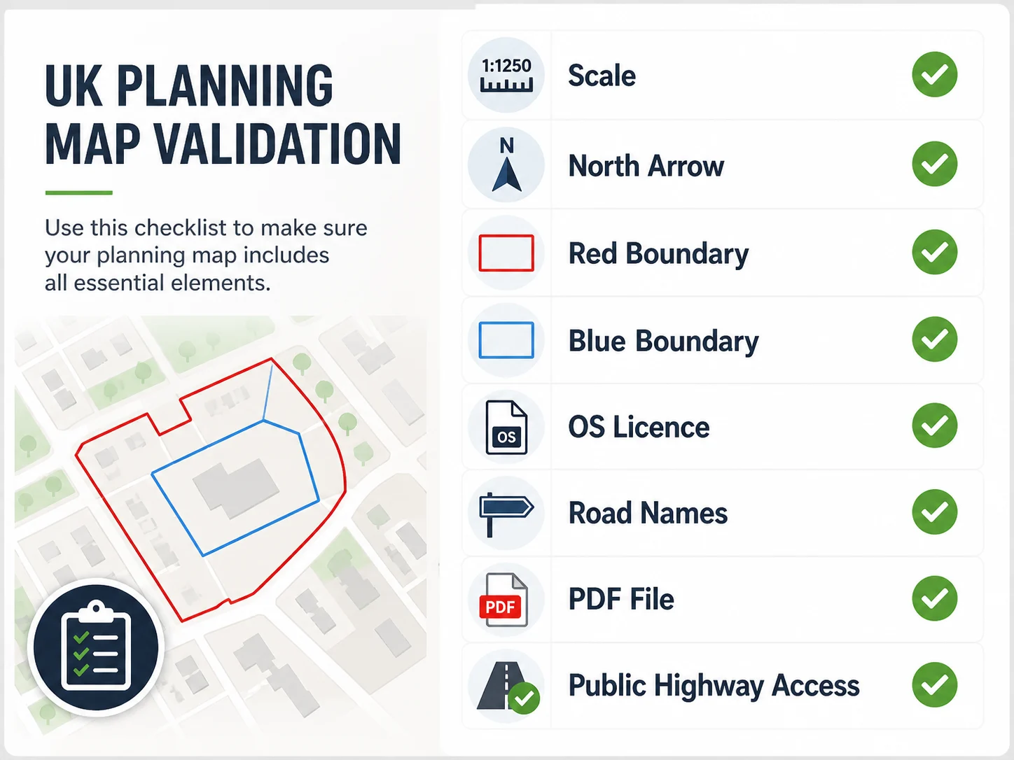
Before uploading, check the basics. Does the location plan show enough surrounding context? Is the scale 1:1250 or, for larger rural sites, 1:2500? Is the red line continuous and complete? Is other nearby applicant-owned land outlined in blue? Are road names, a north point, a scale bar, and OS licence details visible?
Then check the site plan. Does it show the existing site clearly? Does the proposed layout explain what will change? Are buildings, boundaries, access, trees, hardstanding, parking, and adjoining streets shown where relevant? Is the scale 1:500 or 1:200?
Finally, check the files. Use PDF for the submission pack unless the authority has asked for another format. Keep CAD files for the design team, or export them cleanly to PDF. Avoid screenshots and low-resolution images. Name documents clearly.
Final Thoughts
Good planning maps make applications easier to validate and assess. They give the local planning authority the information it needs in a familiar format: correct scale, clear boundaries, north point, surrounding context, and licensed mapping.
The distinction between a location plan and a site plan is simple but important. The location plan identifies the land in its wider setting. The site plan explains the proposed development within and around the plot. PDF is usually best for submission, while CAD is best for design work. When each document does its job, the planning conversation can move beyond avoidable map queries.
Sources: Planning Portal, Planning Portal FAQ, GOV.UK, Ordnance Survey, and City of York.
Property data, one integration
Build with UK property data
Browse our APIs for valuations, sold prices, EPCs, crime, schools, ownership and more.